# How to convert vtkPolyData to image coordinates?
**URL:** https://discourse.vtk.org/t/how-to-convert-vtkpolydata-to-image-coordinates/8108
**Category:** Support
**Tags:** python
**Created:** [March 22, 2022, 3:50pm UTC](https://discourse.vtk.org/t/how-to-convert-vtkpolydata-to-image-coordinates/8108 "2022-03-22T15:50:00Z")
**Posts on this page:** 2
**Page:** 1
### Author:  [@lbrandao](https://discourse.vtk.org/u/lbrandao)
#### Post date: [March 22, 2022, 3:50pm UTC](https://discourse.vtk.org/t/how-to-convert-vtkpolydata-to-image-coordinates/8108/1 "2022-03-22T15:50:00Z")
Dear All,
I have a vtkPolyData file (extension.vtk) with 12 points:
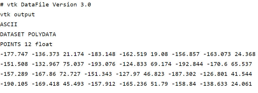
These points are the annotation of a 3D image data (more exactly, a multi-slice DICOM image - one folder with 14 slices/frames .dcm).
I need to convert each of the previous points to image coordinates. I.e. given a point (e.g. -177.747, -136.373, 21.174) I need to find the correspondent (i, j, k) image coordinates (where k is the slice index).
This is what I tried:
```auto
# load 3D volume
volume_reader = sitk.ImageSeriesReader()
dicom_names = volume_reader.GetGDCMSeriesFileNames(multi_slice_volume_path)
volume_reader.SetFileNames(dicom_names)
image = volume_reader.Execute()
# load vtk points
reader = vtk.vtkPolyDataReader()
reader.SetFileName(lmks_vtk_file_path)
reader.Update()
vtkdata = reader.GetOutput()
vtk_points = numpy_support.vtk_to_numpy(vtkdata.GetPoints().GetData())
# convert vtk points to image coordinates
image_points = np.zeros((vtk_points.shape))
for i, coord in enumerate(vtk_points):
coord = (float(coord[0]), float(coord[1]), float(coord[2]))
image_points[i] = np.array(image.TransformPhysicalPointToIndex(coord)).astype(int)
```
But the image coordinates that I get are not correct.
```auto
[[-33. 190. 24.]
[-52. 194. 23.]
[-45. 178. 21.]
[-35. 143. 26.]
[-42. 166. 29.]
[-72. 168. 26.]
[-60. 147. 24.]
[-25. 161. 24.]
[-35. 181. 27.]
[-66. 180. 25.]
[-53. 161. 23.]
[-29. 179. 23.]]
```
I get negative i coordinates (points outside the image boundaries) and the k coordinates are not within the expected range 0-13 (since I have a total of 14 slices).
I did further research but I couln’t find the solution. The closest clue was this post [https://discourse.vtk.org/t/mapping-between-coordinate-position-x-y-z-and-voxel-index/5357/4](https://discourse.vtk.org/t/mapping-between-coordinate-position-x-y-z-and-voxel-index/5357/4) by @dgobbi
Any help will be most appreciated. Thanks.
---
### Author:  [@dave3d](https://discourse.vtk.org/u/dave3d)
#### Post date: [March 22, 2022, 6:32pm UTC](https://discourse.vtk.org/t/how-to-convert-vtkpolydata-to-image-coordinates/8108/2 "2022-03-22T18:32:36Z")
I would guess it has to do with LPS vs RAS coordinate systems. I’d suggest loading the data into Slicer and see if they align. Slicer does a good job of handling all the coordinate system intricacies.