Hi,
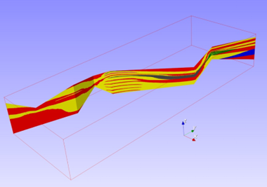
Depends on you what you mean by “handle” and “databases”. If you have the data as Geo-EAS/GSLib plain text files and want to perform some exploratory data analyses, run some estimation/simulation on grids and display them in 3D, then, yes. GammaRay supports data like drillhole/well (either as point sets or segment/polyline sets), regular grids (2D and 3D), stratigraphic grids (good for orebodies and reservoirs) and something dubbed “geologic sections” used to represent, for example, outcrops:
Indeed. GammaRay evolved better suited for petroleum geostatistics/geologic modeling. This means it still lacks some essential features for mining application such as contact analysis and grade-tonnage curves. Anyway, it’s all opensource, you can fork it and modify it any way you want. Although it requires getting acquainted with modern C++.